
My close friend Alyssa and I have had a variably ongoing tradition of visiting one another to get up to some kind of local adventures most Summers. Most recently Alyssa stopped by DC in 2020 while traveling to take care of her grandparents who needed help during the height of the pandemic, and this past Summer of 2021, since everyone finally had access to a vaccine and cases were at a record low since the start, I visited Alyssa and Megan for 10 days in beautiful Rhode Island.
Since this trip was quite long, and included numerous locations and photoshoots, I am breaking this post up into days and major locations, and including highlights linking back to dedicated posts I’ve already posted.
Be sure to see my highlight video of selected clips from this trip, found at the end of this post or at this link on YouTube. Or see the full Vlog on YouTube.
Black Tom Island, Statue of Liberty, Ellis Island, & Manhattan
Like my last trip to Rhode Island in 2018, I chose to drive, both due to the safety risks of flying, and the logistical ease of having my car on hand. With a new pair of Maui Jims in my signature color, a new dashcam installed, and Ginny, my plush Corgi Alyssa sent me earlier in the year, riding shotgun, I had my car freshly ceramic tinted the day before leaving, which made the Summer heat and sun much more bearable with the extended drive - a light smoky look, I regret not having my black car with black interior tinted the day I bought it in 2015. Unfortunately, I was traveling on 4th of July weekend, which meant my ~7-8hr drive ended up being about 16hrs thanks to traffic the first half and severe weather from New York forward.

Approaching New York, I was driving on the border of a massive rainstorm the length of the Eastern seaboard, whose bands were spaced out like fingers but I somehow was able to outrun just enough to arrive at my traditional halfway stopping point of the Jersey shore overlooking Manhattan, this time at Black Tom Island. The pavement was drenched from a band that had gone through probably not long before I arrived, and I knew from watching radar I didn’t have much time to go get a glimpse of The Statue of Liberty - this was my first time at this park, so while I knew I *should* be able to spot it, I wasn’t sure how great the view would be.
Black Tom Island’s park seemed very nice, or at least it would be when the facilities are open - I suspect the visitor center was a pandemic closure, but given the nasty weather the only people out and about were two couples dropping in to take a quick selfie with Lady Liberty like I was, and a runner so saturated he looked as though he’d just arisen from the Hudson. Black Tom Island is a part of Liberty State Park I’d like to visit more in detail knowing a bit more of the history behind it - the site of the Black Tom Explosion in 1916, German spies set fire to the Lehigh Valley Munitions Depot housing 2,000,000 lbs of artillery shells and 100,000 lbs of TNT to be shipped to Russian and British allies during WWI. The sabotaged stockpile detonated, destroying the manmade island, launching debris into the skin of The Statue of Liberty and buildings over a mile away, shattering windows up to 25mi away, registering 5.5 on the Richter Scale, being felt as far away as Philadelphia and heard as far as Baltimore.
The incident resulted in creation of The Espionage Act of 1917, and later would later be used by FDR as justification for the internment of Japanese Americans during WWII. Today the site of the explosion is marked with a circle of flags with Lady Liberty holding her damaged and now restored torch high above her head, perhaps peeking over her shoulder at blast site.

I hurried to the Hudson’s shore to get a peek at the Statue of Liberty, Manhattan, and maybe Ellis Island before the storm caught back up to me. I was lucky; I got there just in time to see Manhattan become completely enveloped in a wall of rain reminiscent of a disaster movie in a matter of a minute. Ellis Island was visible but not discernible. I didn’t wait to see Lady Liberty, parallel to my unsheltered position, to also be consumed. I had another traveler (apparently also from DC on their way up to New England) quickly take my picture, shot a few Polaroids, and sprinted the 1/4mi back to the car as heavy raindrops began pelting me - it had been drizzling the entire time, but it was about to get serious again.
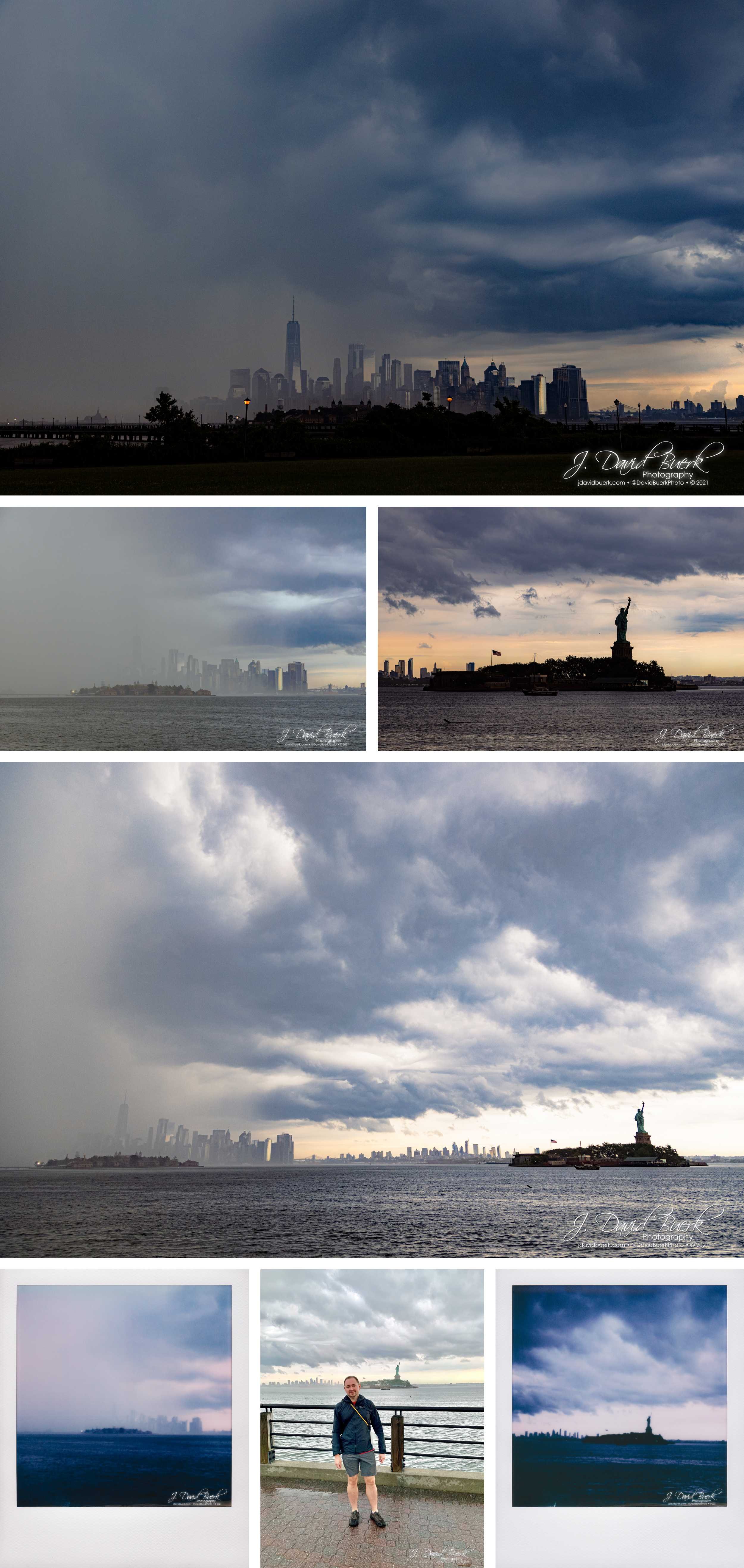
By time I got to my car the rain was just picking up; I spent only 10min at the park. This would be the weather I’d drive in for the next ~8 hours on a trip that would normally only require 4; a long day of driving non-stop without even eating anything more than my morning coffee that would result in a migraine the next day after finally arriving.

Alyssa, Megan, and myself all grumpily went straight to bed once I finally got there and collapsed from a long day of hurry up and wait. Isla quickly became my new best friend and kept me cozy and cuddled on Megacouch™ that was my bed for the trip every night. The next morning I met Nova, who I’d only Facetimed with up to this point, and once my migraine had subsided enough that light and sound weren’t cracking my skull open, Megan and I got weird in her new plague reaper outfit. I also might have accidentally scared a few people wearing this mask while walking around in a few spots that required masks - Megan and I share a love of dark humor and literally morbid curiosities. We had several ideas for photoshoots with this getup, but didn’t have the time to pursue them, and had higher photoshoot priorities.

Slatersville
I’ve learned over the years that the best trips only have loosely laid plans; you need to be able to follow your heart, not an itinerary. Rhode Island, and all of New England for that matter, has rich and interesting history, whether local or regionally. Most days on this trip I started like most days at home, by knocking out a run - I kept them short to only 5Ks on the road, and this time had a running buddy: Isla, who is a bundle of energy. None of us were sure how she’d do running that long a distance; our first few times out I stopped variably to give her a check-in and rest, but over the course of a few days I’d worked her up to the full 5K distance non-stop, and she did great! After just a few runs she had even learned the new commands, “let’s go” to speed up, “slow down,” and most critically “cross” for knowing when I was deeming it safe for us to cross roads and crosswalks - she’s a very smart pupper, and I miss my running buddy after coming back home!

Typical of New England Summers, there were numerous dreary days, which I of course enjoy my fair share of, and they work perfectly for some of the photoshoot ideas Megan and I had bouncing around. Once my headache cleared more, we set out to go scouting for some of the steampunk and vintage shoot locations. This actually would have been a perfect day to shoot on, but neither of us were in the mood for more than just some casual exploration.

Fun fact; I hint at it in the Victorian Trenchcoat Photoshoot’s post, but on the other side of this wall Megan climbed onto and lay atop was this piece of power gathering equipment leftover from the textile mill’s spillway - the water rushing through was very loud and very dangerous, so I’m still surprised she scaled up, laid down, and closed her eyes without hesitation.

On another day, I went walking with Alyssa, some of her neighbors, and the puppers on a play-date-walk around Slatersville; I’d seen much of the small village from my runs, but certainly not all of it, such as the nearby reservoir’s feed into the mill’s spillway above about ½mi away where Isla and the other puppers like to go swimming before the current picks up.

That evening Megan and I went out stormchasing, one of two times we rushed out to try and catch lightning. This is something we both do in our respective hometowns during the thunderstormy Summer months, but was the first time we’ve had the chance to go do it together, not just frantically texting each other about storms in our area. As it turns out, we both have very different methods of photographing storms and capturing lightning photography; although my method is more traditional, I have to give the aptly named “@thestorm_witch” the win here, because she routinely catches more lighting more aesthetically than I do. Don’t tell her I admitted she’s better than me LOL.

Independence Day
On The 4th of July I went with Alyssa to her mom’s for a BBQ and birthday party for one of the kids; not only were most of Alyssa’s family who I’ve come to know over the years were there, but also quite a few of Alyssa’s friends, which was nice to see again after 3 years. This was also my first time seeing Hennessy, her sister’s pit who fell in love with me in 2018 just as much as Isla this 2021 - I have a reputation of stealing the hearts of everyone else’s pets 💁🏼♂️ Between the two, it turned into a flight of who would be my lap dog during the picnic, but since Hennessy has gotten a bit older, chubby, and lazy, Isla won this fight. Alyssa brought her albino bunny Ghost, who was fed by some of the fascinated kids when he wasn’t exploring her garden and nibbling on the veggies ready for harvest.

After the party, a group of us met up to make smores and drink around a firepit after a dip in the hottub as fireworks went off in different directions around us.

Megan: Steampunk Textile Mill
The next day Megan and I shot our first session together inside the textile mill, which had some equipment leftover and restored for display; perfect for the steampunk vibe we were after. This was Megan’s first time modeling in over 5 years, and her first time in a corset, so I’m glad she was comfortable entrusting me with photographing her and jumping back into modeling with me.
A few highlights are below, but you can see the full set and a more detailed description of our concept on this post dedicated to the shoot.


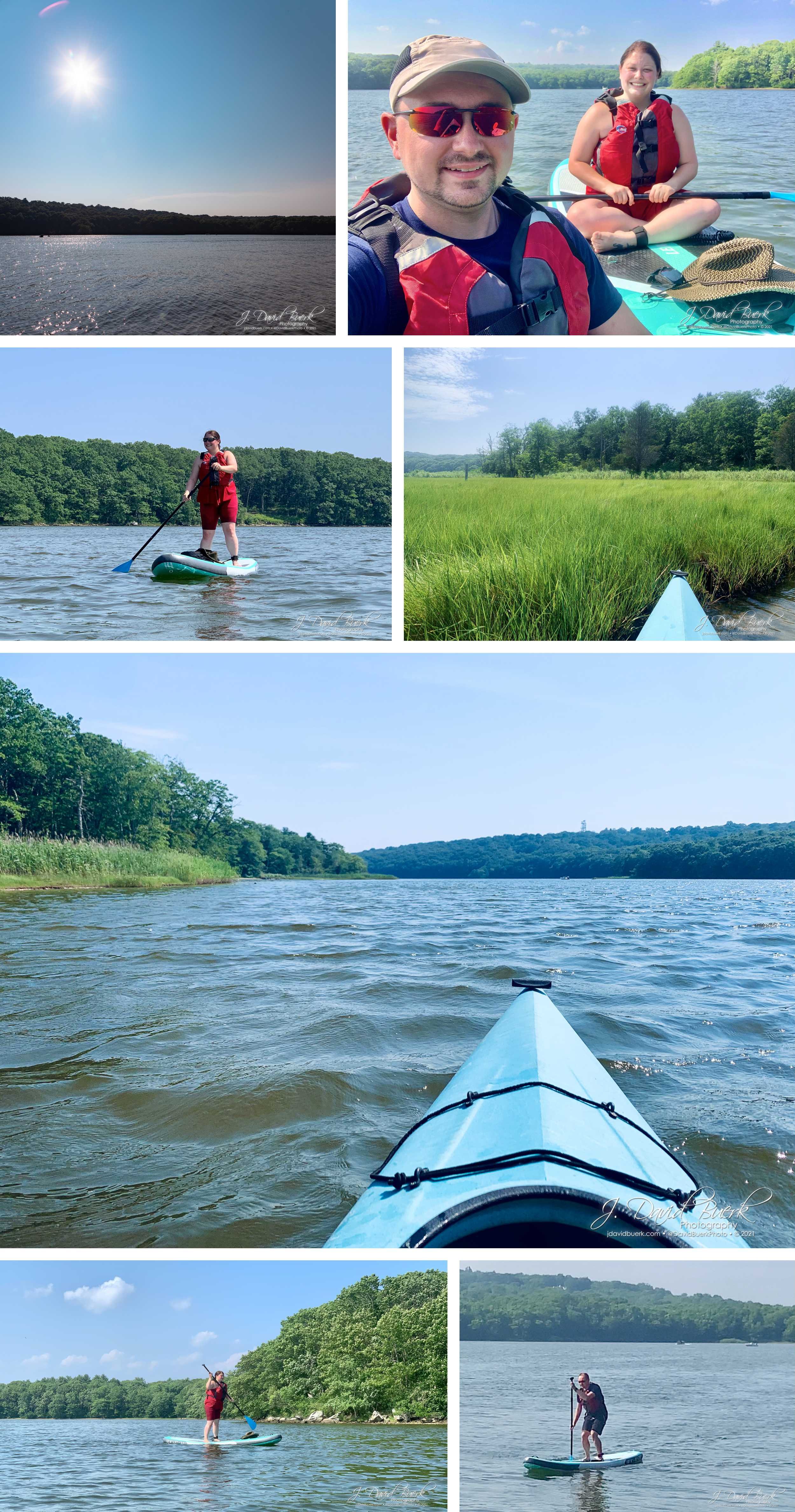
Paddleboards and Kayaks
For several months Alyssa had been excited about the inflatable paddleboard she had gotten a deal on, and this day was a great opportunity to give it a shot. I enjoyed some kayak time along Saunderstown’s Narrow River while Alyssa quickly got the hang of her board - she has the goal of getting Isla to be comfortable riding along with her, but her first time on a paddleboard isn’t the time for that - the pupper stayed home. Even I gave the paddleboard a shot after Alyssa was done, though it was beginning to deflate and become a bit floppy, but I am still impressed at how similar to a fully rigid paddleboard it is.

Wickford
After a day on the water, it was time to head over to nearby Wickford for drinks and lobstah rolls at Wickford on the Water. Most of the shops in downtown Wickford were already closed for the day so while I walked around and took pictures with my Canon, so I came back a few days later to do some shopping with only my Polaroid.


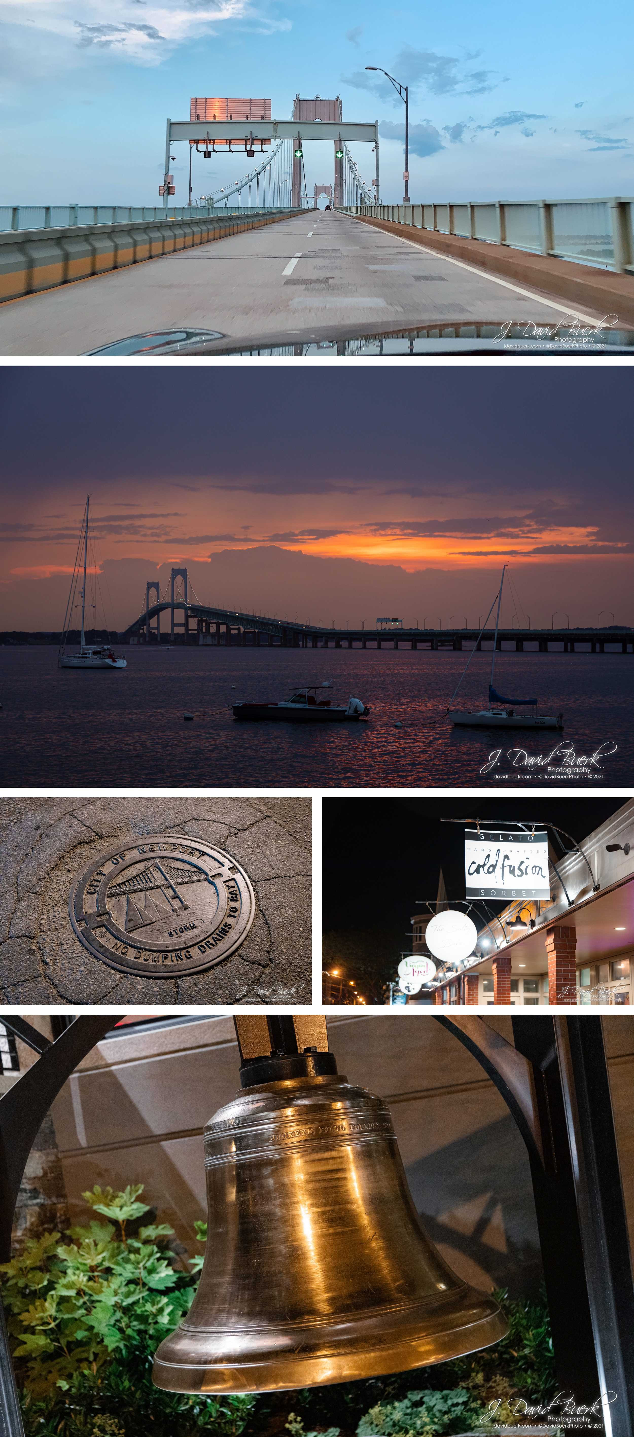
Newport
After Wickford, I head over to Newport solo in search of sunset and to see what the nightlife was like this time around - I parked in the same spot I did 3 years prior, and walked Thames Street like I did in 2018. None of the boutiques were open; just the touristy oceanwear stores that don’t offer the individualized type of gifts I was on the hunt for. I wanted dessert; perhaps a drink, but definitely ice cream - there was a gelato place I popped into as a nightcap in 2018, and to my delight it was still there and one of the few places also still open at this hour. A fitting tradition I’ve come to develop in this city.
Megan: Victorian Trenchcoat
This day we’d awaited foggy weather, and jumped at the fog offered this morning before the sun rose enough to burn it off. The fog provided the perfect atmosphere to match the damp ruins of the old textile mill, a setting matched to the Victorian trenchcoat Megan and timeless makeup Megan sported for this photoshoot.
Enjoy some highlights below, but be sure to visit the dedicated post for more of the images we created during this shoot. For this shoot I also brought my Polaroid and captured some true beauty in imperfection.


Boston
One of the biggest plans I had for this trip was visiting Boston. I technically had been before, back in 2000, the same trip that I shot my September, 2000 photo of the World Trade Center which I revisited and replicated in 2018 on my last roadtrip up to New England. But my only memory of Boston besides seeing The Old North Church is riding my Razer scooter through a busy market, one I remember as being Chinatown, but after this trip I must wonder if it was the Boston Public Market I walked through first thing upon arriving in the city.
Immediately after wrapping the Victorian Trenchcoat shoot, only taking the time to offload the pictures, I zipped off solo the hour drive to Boston, dropping my car next to Quincy Market to grab a lobstah roll before starting my explorations. Passing through the Boston Public Market, I spotted Union Oyster House, noting it as a possible dinner option for later.


After some chowdah and lobstah, I began my exploration. Like how I explore most new cities, I didn’t have any firm destinations - I happened upon nearby Christopher Columbus Waterfront Park and took in Union Wharf on my way up to The North End, where The Old North Church is located among a number of cemeteries.

Entering The North End, I was drawn down down Hanover by the residential architecture, and stumbled upon the All Saints Way alleyway shrine in Boston’s little Italy. Owned by resident Peter Baldassari, this little known odditiy is a collection of photos, statues, prayer cards, and holy objects collected throughout his life, and partially on display in the private alleyway outside his home. 2021 has unironically been my year for Atlas Obscura, because I visited Centralia, a Pennsylvania ghost town expected to burn for the next 250 years, just a few months prior to this trip, and here I am visiting another registry in the Atlas Obscura.
But wait, there’s more! After walking through Paul Revere Mall and The Old North Church’s grounds, I, again accidentally, stumbled onto the Skinny House, AKA The Spite House, another Atlas Obscura entry. This 10 foot wide, 30 foot deep 4 story rowhouse is the result of a feud between two brothers following an inheritance / land-rights dispute after the Civil War. One brother, arriving home from the Civil War prior to his brother, built a home on the site; when his brother returned later and felt the land leftover in the inheritance had been disproportionally taken, the Skinny House was built out of spite to block the first brother’s access and daylight exposure to his home and business. Today the Spite House remains the skinniest house in Boston; the historic building is privately owned and occupied, and not open to public.

I walked by The Old North Church, but without plans to actually tour it - I couldn’t have if I wanted to anyway; it was closed.
Unfortunately all the cemeteries in Boston had also just closed by this time; 4PM is very early, but my understanding is the time is set this way to deter vandalism of the gravestones dating back hundreds of years, so the graveyards always close at least an hour before sunset no matter the status of Daylight Savings Time - this reasoning needs a citation to confirm, however.
I was still able to see into the many cemeteries I passed by, and poke my camera through the fencing to get better views.

Continuing on, I made my way to Converse - Lovejoy Wharf and crossed the bridge with the intention of visiting The Charlestown Bells, but the entire dock this musical public art installation is located on was closed for construction.


Since that was a bust, I decided to check out Paul Revere Park. I didn’t think this was really the type of thing I was looking for, but I was thinking of heading the general direction of Bunker Hill, so it was worth popping into. I’m glad I did, because it offered a great view of the city, including TD Garden and Leonard P. Zakim Bunker Hill Memorial Bridge.

Since this was a bit of a breather and I was figuring out where to go from here, I found that Bunker Hill, like the cemeteries, was also closed for the day, and there wasn’t anything else in that direction I was drawn to - I’m sure I’d have found something fun that way on my exploration, but I like having a general direction in mind, even if I don’t necessarily make it to the destination I choose to head toward. I shifted my focus toward MIT, Southwest of my current location, and figured it might be interesting to walk through. This lead to my favorite happy accident of my entire trip.

Crossing the North Bank pedestrian bridge, I wasn’t sure I’d made the right call, but when I got to the other side of the water under I-93, I knew I’d accidentally made an even better call than I could have planned. The Lynch Family Skatepark came into view, and it was hopping. After watching from the bridge for a few minutes, I made my way over to get a closer look.
The skatepark is one of only a handful in all of Boston, and is the result of a non-profit that built it was part of a waterway restoration project 6 years ago. The park clearly attracts skaters of all ages and skill levels, from kids on their first set of rollerblades to adults older than me tearing up the bowls on skateboards. BMXers and scooters also dropped in for some action in the brightly graffitied bowls and ramps with street art applied. Looking through historical photos, the park was totally barren of color and art until recently, and I’m glad they now allow, or at least don’t seem to enforce, graffiti rules or removal, if any. Like Centralia’s Graffiti Highway, the colorful expression through art and messages is important, beautiful, and hurts nobody. Here is provides a beautifully textured backdrop for skaters’ athleticism.
I perched myself in a visible, but out-of-the-way position on the lip of the largest and most skated bowls, and captured skaters as they dropped in and let ‘er rip. Several even made sure to incorporate paths and tricks up close to my spot for me to catch, and even came by to check out what my results were.
I spent almost an hour hanging out, watching, seeing what I could see, and enjoying the chill vibe here. It’s stumbling onto awesome spots and experiences like this, through pure accidental luck while, that I love about aimlessly exploring new cities like this.


At this point it was getting toward the golden hour, and I didn’t want to be *too* far from my starting point once night fell; I have no problem staying out in a new city after dark (I actually enjoy it), I just didn’t feel like needing to hail a cab to get back to my start like I did on one of my Chicago trips - another time. I scrubbed MIT and decided to go see the original Cheers pub, but without intention of eating there; not only do I prefer to avoid obvious tourist traps, but also looking at their menu beforehand, all they serve is crappy, super basic bar food and light beers - not worth eating there, especially if there’s a wait, which of course there was a line waiting outside when I did eventually get there.
Making a loop, I skipped the West End entirely and cut through Massachusetts General Hospital, which I didn’t mind because I love medicine and beautiful architecture.
I made my way through Beacon Hill, which I’d have liked to have spent more time in shopping and dining, however, like my time in Wickford, all the shops I was interested in visiting were already closed for the day. Instead, I started ducking down interesting looking sidestreets to take in the historic architecture and househunt in this expensive residential area.

Exiting onto the famed Beacon Street, I poked my head into Cheers to at least see the interior for myself, and snapped a few pictures of the exterior before crossing into the Boston Public Garden across the street.

Boston Public Garden was a non-rushed shortcut for me on my way back to Downtown for dinner. I made my way generally toward the other side, enjoying the scenery along the way.


After passing by another (closed) cemetery, I was drawn by Emerson College’s pretty buildings, and followed some interesting looking sidestreets. This ended up landing me in Boston’s theater district, which I didn’t even know existed. As the sun was just setting, I was here at the perfect time to capture all the colorful blinking lights with dusk’s vibrance in the sky.

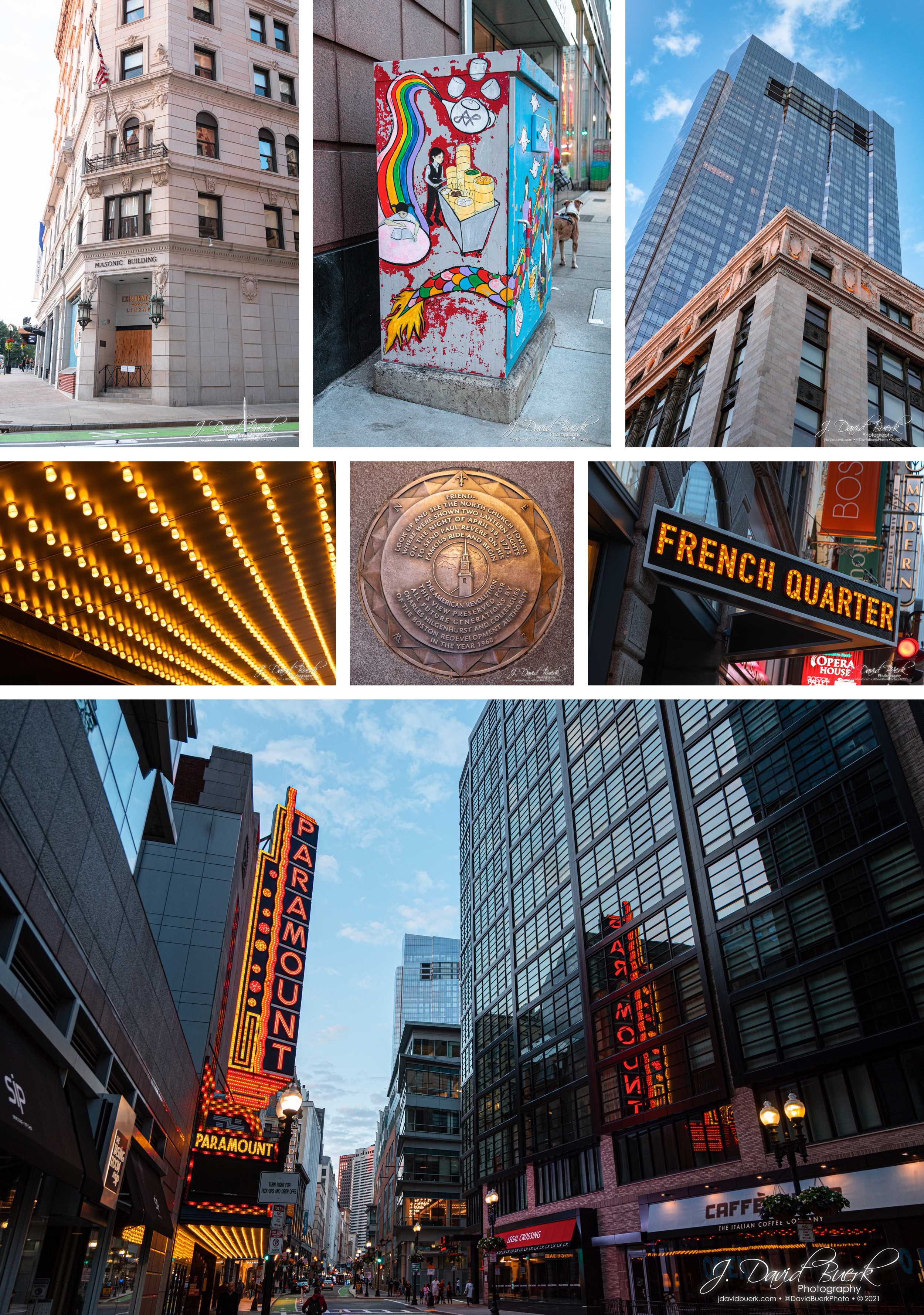

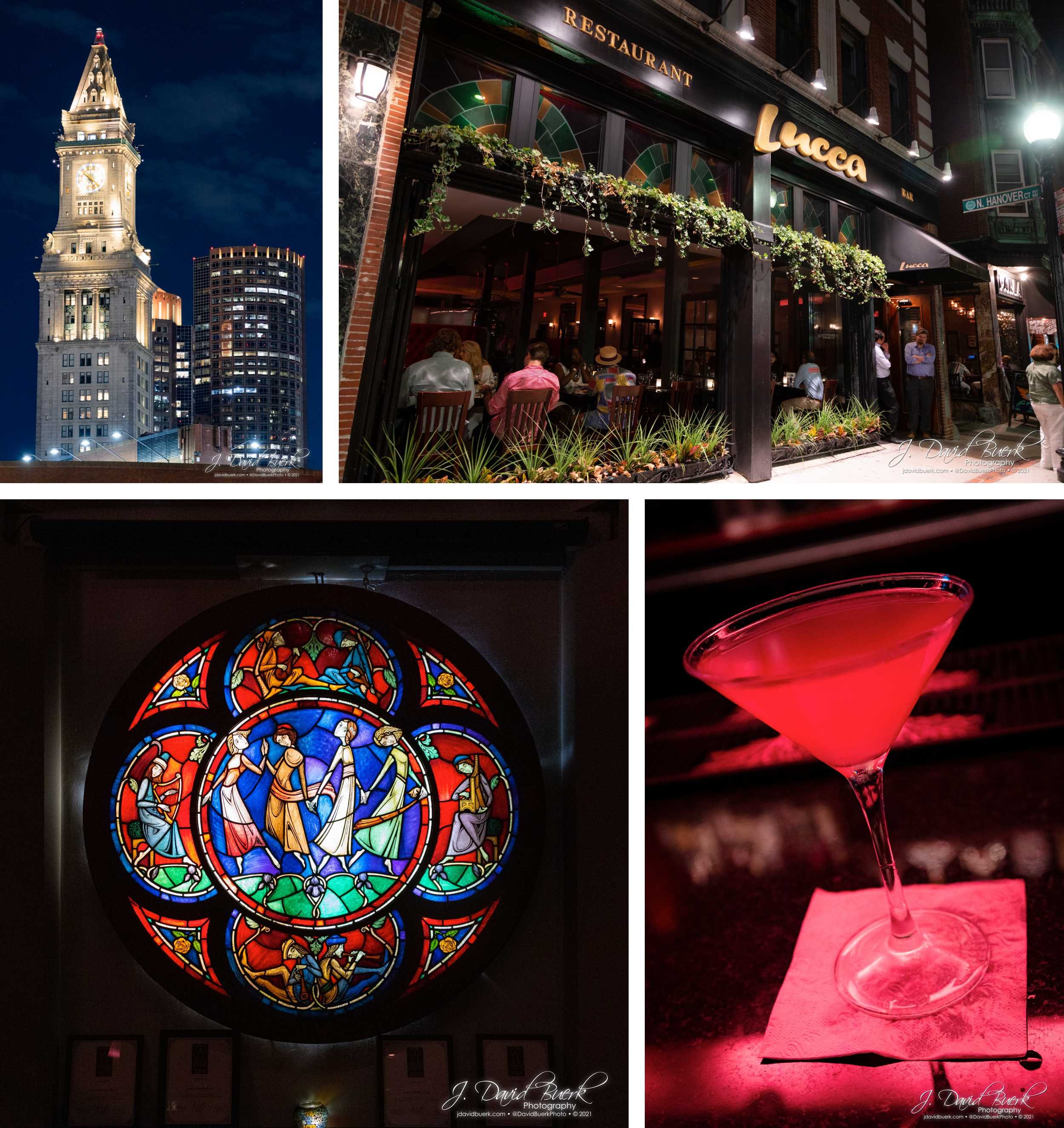
Quincy Market had far fewer people on the plaza by time I made it back, and after some casual looking at my dinner options, I decided Union Oyster House was my spot - I had been curious since I laid my eyes on it at the beginning of my day, and it offered some of my favorite foods: oysters, seafood, and cocktails.

Oof, it hit the spot. At this point, I was pretty beat from the day, and done with exploring, but I wasn’t done with the city. I decided to walk around and find bar to see what the Boston nightlife is like. I found myself a few blocks away at Lucca, a fine Italian offering whose entire front was open to enjoy the nice weather and music from their bar illuminated a dim pink. I had several sidecars with my oysters and seafood platter at dinner, and switched to martinis to round out my evening.
Chill Day: Bunny Grooming, Farmer’s Market, Wright’s Dairy Farm
Although I was busiest, touring Boston, the day prior, everyone was on board for a day of leisure. Alyssa groomed Ghost al fresco while Megan and I poked around with our cameras.

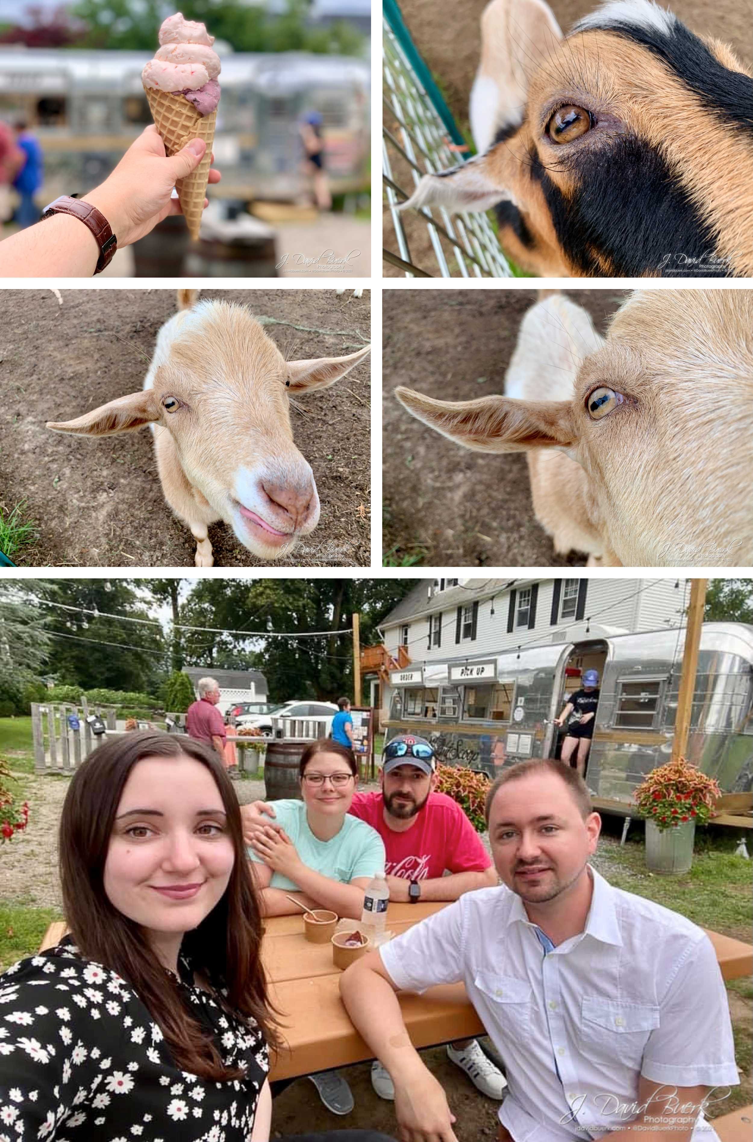
Next we head over to pick up Alyssa’s order from her farmer’s market, and said hi to the goats before heading over to Wright’s Dairy Farm (which you can see pictures of from my 2018 trip) for fresh ice cream, and to pick up a cornucopia of treats. On the way back, we picked up pizzas and played shuffleboard for the night.
Last Day, Departure, Darien
My last day in town was another workday for both Alyssa and Megan; I grabbed lunch with Megan, then head back to load my car and hang out with Alyssa and Isla for a few hours before needing to hit the road. Isla made it *very* clear she wanted to come home with me, but alas, all I brought home were some paw prints, fur, and part of a bouquet Alyssa assembled and placed in my cupholder to deliver to my mom.

The drive back home was MUCH easier than the drive up a week prior; I hit no traffic and no weather. Around dusk I was getting hungry and decided to pull off at a convenient exit in Connecticut. I parked at a Starbucks and opened my phone to see what local flavors were around and open - I lucked out, because I was in the mood for a burger, and had parked across the street from Burgers, Shakes, & Fries, and it was one of the few places still open in this small town. Walking over is when I realized exactly *where* I was - this was Darien, Connecticut, which wouldn’t normally be notable except one of my best friends grew up here. After sitting down and ordering my cholesterol special with extra onions and a side of onion rings, I texted my friend Patrick to let him know where I was and get his childhood home’s address - it was only 5min away.

After inhaling that delicious burger, I went for a quick walk along Darien’s Main Street. The sun was setting and everything was closed, but this I expected, and wasn’t set on shopping anyway.

After documenting a very patinaed Chevy across from my car, I head over to Patrick’s childhood home to document it as night fell, because I knew he’d appreciate seeing it and it wasn’t out of my way at all.

After this I set back on my way South to DC, with a mostly uneventful late-night drive the entire way; how I’m used to this trip going. This time I skipped stopping to view Manhattan, as I counted Darien as my mid-trip stop this time around.

Highlight Vlog
See highlighted video clips in this video below, or watch the full Vlog on YouTube.
I don’t know when the next time I’ll be returning to New England will be, but I do want to make sure to get out to Salem next time around!


